Looking Ahead: EDITO at the UN Ocean Conference 2025

From 2–13 June 2025, the international ocean community will gather in Nice, France for the Third United Nations Ocean Conference (UNOC). EDITO will be present throughout the event, participating in high-level sessions and demonstrations at the European Digital Ocean Pavilion, which will be located in the Green Zone – The Whale.

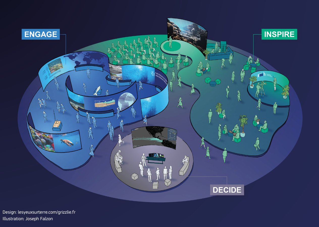
Organised by the European Commission’s DG DEFIS in partnership with DG RTD, DG MARE, and DG INTPA, and implemented by Mercator Ocean International, the Pavilion showcases Europe’s commitment to using digital innovation for sustainable ocean management and global collaboration.

Designed around three immersive zones—INSPIRE, ENGAGE, and DECIDE—the Pavilion offers a dynamic gateway into the EU Digital Twin Ocean. Here, visitors can explore ocean processes, run “What-if” scenarios, and experience real-time insights through interactive displays, simulations, and storytelling tools.

EDITO partners will be participating in numerous events and sessions. To discover EDITO at UNOC, here are some programme highlights:

June 3–5: One Ocean Science Conference
EDITO kicks off with multiple sessions during the One Ocean Science Conference, including a presentation on habitat suitability mapping to protect marine ecosystems and a session on next-generation ocean modelling. An EDITO-led poster exhibition will also run in parallel, showcasing our advances in digital twin applications for coastal resilience.

 June 4: Town Hall – Marine Knowledge at the Fingertips of our Communities
In this dialogue session, EDITO will demonstrate how digital twins bring ocean data directly to communities and stakeholders, fostering inclusivity and accessibility in marine knowledge systems.

June 5: Training Workshop – What-if Scenarios (WiS)
At the INSPIRE Arena, EDITO will lead a hands-on training session for policymakers and practitioners on using What-if Scenarios to explore marine policy impacts—from planning aquaculture to mitigating marine litter and enhancing biodiversity.

June 6: International Weather & Climate Forum
EDITO will participate in a roundtable on future digital ocean apps and deliver a dedicated media workshop, showing how digital ocean tools can strengthen science communication and public engagement.

June 8 & 9: World Ocean Day – DTO for the Ocean Pact
On World Ocean Day (Sunday, 8 June), EDITO will join the global community in celebrating the marine realm and in highlighting the critical importance of protecting our Ocean.

On Monday, 9 June, EDITO will support discussions around the Ocean Pact and how digital innovation can fast-track SDG14, offering new mechanisms for monitoring and protecting marine ecosystems.

June 13: EDITO-Model Lab Hackathon Launch
Closing out the programme, EDITO will launch a multi-partner hackathon focused on developing and testing real-world applications—from oil spill simulation to plastic pollution tracking—directly on the EDITO platform.

EDITO: The backbone of the European Digital Twin of the Ocean

The Ocean Bulletin is an open web platform that helps maritime professionals plan routes at sea factoring meteorological and oceanographic conditions into predicted arrival times, fuel consumption, and CO₂ emissions. This application is meant as an EDITO integration aimed for a global audience, allowing users to simulate voyages anywhere on the global ocean, or between specific ports, and to compare performance across multiple types of vessels.

This application simulates a water column anywhere around the world, allowing users to explore the selected water column’s response to pressures.

This application provides real-time position of the low tide bathymetry line observed from satellites, which is useful for navigability and planning maritime operations.

The Global AI-Ocean Forecasting System (GLONET) provides an on-demand, fast, configurable and interactive framework that can be activated easily and quickly everywhere in Europe and in the world Ocean. ​

This application provides an accurate, resource-efficient and accessible tool for seasonal prediction of chlorophyll concentration. Chlorophyll concentration is an important indicator linked to marine ecosystem health, productivity and fisheries.

This application offers a web interface with a thematic approach to data, allowing users to create maps and graphs and to apply on-the-fly processing to deliver a comprehensive picture of the ocean on a given topic and/or area.

This application aims to improve the modeling of key tuna species spatial dynamics under the influence of essential ocean variables. It uses model projections from the Intergovernmental Panel for Climate Change (IPCC) to explore the future of tuna populations and their fisheries.

This application aims to support coastal and marine planning by enabling proactive responses to sargassum influxes across the Equatorial Atlantic and surrounding Exclusive Economic Zones (EEZs).​

This application shows the impact of ocean observing systems -including in situ observations and satellites observations- on the ocean forecasts from the models. It provides access to information about observations assimilated to model (GLO12) and features to compare simulations with or without observations.

This application provides local information on people and buildings at risk in coastal areas, offering an assessment based on selected parameters, including “Shared Socioeconomic Pathways” (SSPs) scenarios, time scale and types of extreme events.​ This interactive experience about coastal risks and adaptation is powered by the Coastal Climate Core Service (CoCliCo) project.

Simulate the hydrodynamic impact of seagrass on coastal erosion to support coastal protection agency, decision makers and scientists to take nature-based decision. ​Demonstrator based on the What-if Scenario on NBS, developed by HEREON in the frame of the EDITO Model Lab project focused on the Wadden Sea (Germany) and the Songor Lagoon (Ghana).

This application simulates how limiting fisheries during certain months can lower the risk of impacting turtle populations. Harnessing turtle drift simulations developed with Copernicus Marine products, and using EDITO, the application demonstrates how ocean knowledge and modelling can be used to protect biodiversity.

This application provides information on the exposure of local regions to plastics coming from terrestrial origin, including level of exposure, origins and travel time. It provides “what-if” scenario options to examine the effect on the local exposure footprint of potential reductions of plastic emissions at (distant and local) source.

This application presents the EU infrastructures -the in situ and satellite observing systems- underpinning the development of the EU Digital Twin Ocean and the stakeholders involved.​