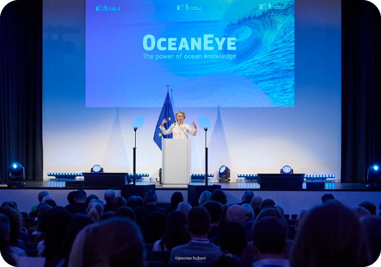
Newsletter

>
Newsletter

Newsletter IV – May 2025

Meet EDITO at the UNOC 2025 ISSUE IV | May 2025 To the EDITO Community We’re delighted to reconnect with you with a fresh update on our shared effort to make ocean knowledge accessible to all. As momentum builds around the European Digital Twin Ocean platform (EDITO), we’re proud to reflect on…

Newsletter III – July 2024

Unveiling the European Digital Twin Ocean: A DOF 2024 Recap ISSUE III | July 2024 Welcome to another edition of the EDITO newsletter! In this issue, discover highlights from the third edition of the Digital Ocean Forum (DOF), held in Brussels (Belgium) on 12-13 June 2024. A flagship event for the European Digital…

Newsletter II – May 2024

EDITO Newsletter ISSUE II | May 2024 In this issue: EDITO at the UN Ocean Decade Conference Upcoming opportunities to engage with EDITO EDITO at the European Maritime Days 2024 Gearing up for the Digital Ocean Forum 2024 EDITO’s latest developments for optimised experience and broader capabilities Read about EDITO’s involvement…

Newsletter I – January 2024

Happy New Year From EDITO ISSUE I | January 2024 As we welcome the new year, we are thrilled to highlight EDITO’s key achievements in 2023 and share upcoming milestones and events towards the co-creation of the European Digital Twin Ocean (EU DTO). Our teams, working on Horizon Europe projects EDITO-Infra…

The Ocean Bulletin is an open web platform that helps maritime professionals plan routes at sea factoring meteorological and oceanographic conditions into predicted arrival times, fuel consumption, and CO₂ emissions. This application is meant as an EDITO integration aimed for a global audience, allowing users to simulate voyages anywhere on the global ocean, or between specific ports, and to compare performance across multiple types of vessels.

This application simulates a water column anywhere around the world, allowing users to explore the selected water column’s response to pressures.

This application provides real-time position of the low tide bathymetry line observed from satellites, which is useful for navigability and planning maritime operations.

The Global AI-Ocean Forecasting System (GLONET) provides an on-demand, fast, configurable and interactive framework that can be activated easily and quickly everywhere in Europe and in the world Ocean. ​

This application provides an accurate, resource-efficient and accessible tool for seasonal prediction of chlorophyll concentration. Chlorophyll concentration is an important indicator linked to marine ecosystem health, productivity and fisheries.

This application offers a web interface with a thematic approach to data, allowing users to create maps and graphs and to apply on-the-fly processing to deliver a comprehensive picture of the ocean on a given topic and/or area.

This application aims to improve the modeling of key tuna species spatial dynamics under the influence of essential ocean variables. It uses model projections from the Intergovernmental Panel for Climate Change (IPCC) to explore the future of tuna populations and their fisheries.

This application aims to support coastal and marine planning by enabling proactive responses to sargassum influxes across the Equatorial Atlantic and surrounding Exclusive Economic Zones (EEZs).​

This application shows the impact of ocean observing systems -including in situ observations and satellites observations- on the ocean forecasts from the models. It provides access to information about observations assimilated to model (GLO12) and features to compare simulations with or without observations.

This application provides local information on people and buildings at risk in coastal areas, offering an assessment based on selected parameters, including “Shared Socioeconomic Pathways” (SSPs) scenarios, time scale and types of extreme events.​ This interactive experience about coastal risks and adaptation is powered by the Coastal Climate Core Service (CoCliCo) project.

Simulate the hydrodynamic impact of seagrass on coastal erosion to support coastal protection agency, decision makers and scientists to take nature-based decision. ​Demonstrator based on the What-if Scenario on NBS, developed by HEREON in the frame of the EDITO Model Lab project focused on the Wadden Sea (Germany) and the Songor Lagoon (Ghana).

This application simulates how limiting fisheries during certain months can lower the risk of impacting turtle populations. Harnessing turtle drift simulations developed with Copernicus Marine products, and using EDITO, the application demonstrates how ocean knowledge and modelling can be used to protect biodiversity.

This application provides information on the exposure of local regions to plastics coming from terrestrial origin, including level of exposure, origins and travel time. It provides “what-if” scenario options to examine the effect on the local exposure footprint of potential reductions of plastic emissions at (distant and local) source.

This application presents the EU infrastructures -the in situ and satellite observing systems- underpinning the development of the EU Digital Twin Ocean and the stakeholders involved.​